
Faça uma doação
Mapa topográfico Maries Village II Phase 2
Clique no mapa para exibir a altitude.
Faça uma doação
Sobre este mapa
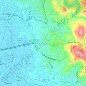
Nome: Mapa topográfico Maries Village II Phase 2, altitude, relevo.
Altitude média: 38 m
Altitude mínima: 8 m
Altitude máxima: 146 m
Faça uma doação
Outros mapas topográficos
Clique em um mapa para visualizar sua topografia, sua altitude e seu relevo.
1920
Philippines > Rizal > Taytay
The shape of Taytay is rectangular – trapezoidal with gently hilly rolling terrain on its eastern side while relatively flat on its south-western side, including the poblacion. The municipality's highest elevation ranges from 200 to 255 meters which is situated along the inner north-eastern hills of Barangay…
Altitude média: 49 m
Faça uma doação
Muzon
Philippines > Rizal > Taytay
The shape of Taytay is rectangular – trapezoidal with gently hilly rolling terrain on its eastern side while relatively flat on its south-western side, including the poblacion. The municipality's highest elevation ranges from 200 to 255 meters which is situated along the inner north-eastern hills of Barangay…
Altitude média: 28 m
Faça uma doação