
Faça uma doação
Mapa topográfico Homer
Clique no mapa para exibir a altitude.
Faça uma doação
Homer
Many of the birds seen during the festival can be identified with the help of published guides that categorize distinguishable features such as, topography, silhouette, size, and color.
Faça uma doação
Sobre este mapa
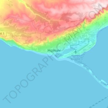
Nome: Mapa topográfico Homer, altitude, relevo.
Local: Homer, Kenai Peninsula, Alaska, United States (59.59827 -151.65504 59.68130 -151.40400)
Altitude média: 104 m
Altitude mínima: 0 m
Altitude máxima: 449 m
Faça uma doação
Outros mapas topográficos
Clique em um mapa para visualizar sua topografia, sua altitude e seu relevo.
Homer
United States > Alaska > Kenai Peninsula > Homer
Some birds seen during the spring migration and the festival include horned puffins, sandhill cranes, and arctic terns. Arctic Terns are famous for flying the longest distance of any migrating bird. Many of the birds seen during the festival can be identified with the help of published guides that categorize…
Altitude média: 106 m
Faça uma doação
Faça uma doação
Faça uma doação