
Mapa topográfico Kirchehrenbach
Mapa interativo
Clique no mapa para exibir a altitude.
Sobre este mapa
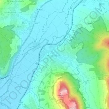
Nome: Mapa topográfico Kirchehrenbach, altitude, relevo.
Altitude média: 320 m
Altitude mínima: 271 m
Altitude máxima: 516 m
Outros mapas topográficos
Clique em um mapa para visualizar sua topografia, sua altitude e seu relevo.
Forchheim
Deutschland > Bayern > Landkreis Forchheim
Forchheim, Landkreis Forchheim, Bayern, 91301, Deutschland
Altitude média: 299 m
St. Walpurgis
Deutschland > Bayern > Landkreis Forchheim > Kirchehrenbach
St. Walpurgis, Kirchehrenbach, Kirchehrenbach (VGem), Landkreis Forchheim, Bayern, 91356, Deutschland
Altitude média: 347 m
Hallerndorf
Deutschland > Bayern > Landkreis Forchheim
Hallerndorf, Landkreis Forchheim, Bayern, 91352, Deutschland
Altitude média: 295 m