
Faça uma doação
Mapa topográfico Lone Butte
Clique no mapa para exibir a altitude.
Faça uma doação
Lone Butte
The northward advance of the Pacific Great Eastern Railway (PGE) rail head passed through Lone Butte in late April 1919. This construction camp had a large kitchen employing 25 cooks, of whom two received the Distinguished Conduct Medal and three the Military Medal during World War I. At an elevation of about 1,140 metres (3,740 ft), the former station was the highest on the line.
Faça uma doação
Sobre este mapa
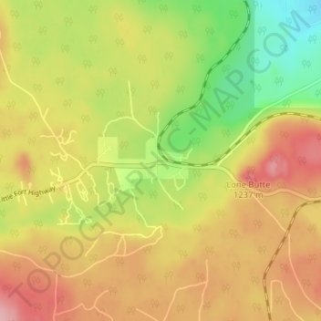
Nome: Mapa topográfico Lone Butte, altitude, relevo.
Altitude média: 1.159 m
Altitude mínima: 1.084 m
Altitude máxima: 1.225 m
Faça uma doação
Outros mapas topográficos
Clique em um mapa para visualizar sua topografia, sua altitude e seu relevo.
Sheridan Lake
Canada > British Columbia > Cariboo Regional District > Area L (Lone Butte/Interlakes)
Altitude média: 1.127 m
Bridge Lake
Canada > British Columbia > Cariboo Regional District > Area L (Lone Butte/Interlakes)
Altitude média: 1.158 m
Interlakes
Canada > British Columbia > Cariboo Regional District > Area L (Lone Butte/Interlakes)
Altitude média: 1.126 m
Needa Lake
Canada > British Columbia > Cariboo Regional District > Area L (Lone Butte/Interlakes)
Altitude média: 1.192 m
Faça uma doação
Horse Lake
Canada > British Columbia > Cariboo Regional District > Area L (Lone Butte/Interlakes)
Altitude média: 1.097 m