
Mapa topográfico Santa María de la Alameda
Mapa interativo
Clique no mapa para exibir a altitude.
Sobre este mapa
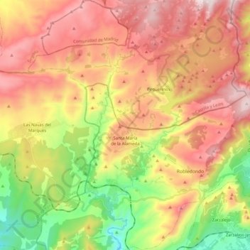
Nome: Mapa topográfico Santa María de la Alameda, altitude, relevo.
Altitude média: 1.339 m
Altitude mínima: 872 m
Altitude máxima: 1.783 m
Originally a group of cattle-raising hamlets, the municipality comprises different settlements: Las Herreras, El Pimpollar, La Hoya, Navalespino, La Paradilla, Robledondo, Santa María de la Alameda and Santa María Estación. In time, the nucleus of "Santa María Estación", developed around the railway station, has grown to become the most populated settlement. The capital of the municipality (the namesake "Santa María de la Alameda") is located at an elevation of 1,409 metres. The municipality covers an area of 74.41 km2, including the exclave of Dehesa de la Cepeda, a mostly pasture area geographically located between the provinces of Ávila and Segovia in the autonomous community of Castile and León.
Outros mapas topográficos
Clique em um mapa para visualizar sua topografia, sua altitude e seu relevo.
Navalagamella
Spain > Community of Madrid > Sierra Oeste
Navalagamella, Sierra Oeste, Community of Madrid, 28212, Spain
Altitude média: 718 m