
Mapa topográfico Dehrn
Mapa interativo
Clique no mapa para exibir a altitude.
Sobre este mapa
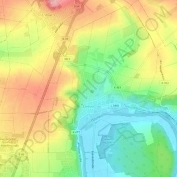
Nome: Mapa topográfico Dehrn, altitude, relevo.
Local: Dehrn, Runkel, Landkreis Limburg-Weilburg, Hessen, Deutschland (50.40497 8.08354 50.44021 8.12188)
Altitude média: 172 m
Altitude mínima: 110 m
Altitude máxima: 242 m
Outros mapas topográficos
Clique em um mapa para visualizar sua topografia, sua altitude e seu relevo.
Arfurt
Deutschland > Hessen > Landkreis Limburg-Weilburg > Runkel
Arfurt, Runkel, Landkreis Limburg-Weilburg, Hessen, Deutschland
Altitude média: 213 m
Eschenau
Deutschland > Hessen > Landkreis Limburg-Weilburg > Runkel
Eschenau, Runkel, Landkreis Limburg-Weilburg, Hessen, Deutschland
Altitude média: 209 m
Steeden
Deutschland > Hessen > Landkreis Limburg-Weilburg > Runkel > Steeden
Steeden, Runkel, Landkreis Limburg-Weilburg, Hessen, 65594, Deutschland
Altitude média: 158 m