
Obrigado por apoiar este site ❤️
Faça uma doação
Faça uma doação
Mapa topográfico Ussel
Clique no mapa para exibir a altitude.
Obrigado por apoiar este site ❤️
Faça uma doação
Faça uma doação
Ussel
The community of Ussel is located in the Massif central on the foothills of the plateau de Millevaches. The city itself sits on a hilltop in between the valley of the river Diège and the valley of the river Sarsonne. It is situated at an altitude of 2070 ft (631 m), in the Massif Central on the last buttress of the Plateau de Millevaches. Ussel is crossed by the Green Meridian.
Obrigado por apoiar este site ❤️
Faça uma doação
Faça uma doação
Sobre este mapa
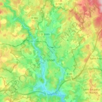
Nome: Mapa topográfico Ussel, altitude, relevo.
Altitude média: 680 m
Altitude mínima: 582 m
Altitude máxima: 845 m
Obrigado por apoiar este site ❤️
Faça uma doação
Faça uma doação
Outros mapas topográficos
Clique em um mapa para visualizar sua topografia, sua altitude e seu relevo.