
Mapa topográfico Finedon
Clique no mapa para exibir a altitude.
Finedon
The town of Finedon rises to approximately 90 metres Above Ordinance Datum from the River Ise, with the historical centre of the settlement occupying a shallow south-west facing valley. The contemporary point of maximum elevation in the parish is the summit of the disused Sidegate Lane Landfill Site, located south of the town at approximately 108 metres Above Ordinance Datum. The parish covers a total area of 1,482 hectares (3,662 acres).
Sobre este mapa
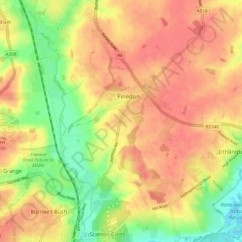
Nome: Mapa topográfico Finedon, altitude, relevo.
Local: Finedon, North Northamptonshire, England, United Kingdom (52.31263 -0.68627 52.36156 -0.62272)
Altitude média: 75 m
Altitude mínima: 34 m
Altitude máxima: 100 m
Outros mapas topográficos
Clique em um mapa para visualizar sua topografia, sua altitude e seu relevo.
Irchester Country Park
United Kingdom > England > North Northamptonshire > Little Irchester
Altitude média: 60 m
River Nene Navigation
United Kingdom > England > North Northamptonshire > Irchester
Altitude média: 55 m