
Mapa topográfico Deddington
Clique no mapa para exibir a altitude.
Deddington
Clifton, Deddington and Hempton stand on a ridge of Jurassic ferruginous marlstone hills between the three watercourses. Clifton is about 1+1⁄2 miles (2.4 km) east of Deddington, at the eastern end of the ridge where it slopes down to the Cherwell. The ridges rises westward. Deddington is about 430 feet (130 m) above sea level. Hempton is about 1+1⁄2 miles (2.4 km) west of Deddington and about 489 feet (149 m) above sea level. The highest point of the ridge is on the western boundary of the parish, more than 490 feet (150 m) above sea level. The parish's topography is alluded to in a local rhyme.
Sobre este mapa
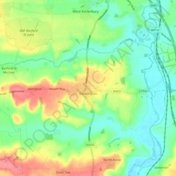
Nome: Mapa topográfico Deddington, altitude, relevo.
Altitude média: 107 m
Altitude mínima: 75 m
Altitude máxima: 159 m
Outros mapas topográficos
Clique em um mapa para visualizar sua topografia, sua altitude e seu relevo.
Roman Meadow Banbury Country Park
United Kingdom > England > Oxfordshire > Cherwell District > Little Bourton
Altitude média: 103 m
Williamscot
United Kingdom > England > Oxfordshire > Cherwell District > Cropredy > Williamscot
Altitude média: 118 m
Stoke Lyne
United Kingdom > England > Oxfordshire > Cherwell District > Stoke Lyne
Altitude média: 116 m
Hampton Gay
United Kingdom > England > Oxfordshire > Cherwell District > Shipton-on-Cherwell
Altitude média: 75 m
Little Chesterton
United Kingdom > England > Oxfordshire > Cherwell District > Wendlebury
Altitude média: 72 m
Down End
United Kingdom > England > Oxfordshire > Cherwell District > Hook Norton
Altitude média: 173 m