
Obrigado por apoiar este site ❤️
Faça uma doação
Faça uma doação
Mapa topográfico Ulverston
Clique no mapa para exibir a altitude.
Obrigado por apoiar este site ❤️
Faça uma doação
Faça uma doação
Sobre este mapa
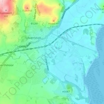
Nome: Mapa topográfico Ulverston, altitude, relevo.
Altitude média: 38 m
Altitude mínima: -1 m
Altitude máxima: 201 m
Obrigado por apoiar este site ❤️
Faça uma doação
Faça uma doação
Outros mapas topográficos
Clique em um mapa para visualizar sua topografia, sua altitude e seu relevo.
Claife Heights
United Kingdom > England > Cumbria > South Lakeland
Claife Heights is an upland area in the Lake District, near to Windermere in Cumbria, England. It has a topographic prominence of 177 metres (581 ft) so is classified as a Marilyn (a hill with prominence of at least 150m).
Altitude média: 141 m