
Obrigado por apoiar este site ❤️
Faça uma doação
Faça uma doação
Mapa topográfico Jackson Island
Clique no mapa para exibir a altitude.
Obrigado por apoiar este site ❤️
Faça uma doação
Faça uma doação
Sobre este mapa
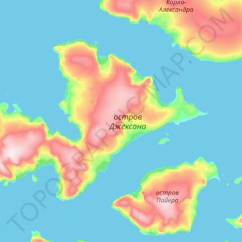
Nome: Mapa topográfico Jackson Island, altitude, relevo.
Altitude média: 82 m
Altitude mínima: -1 m
Altitude máxima: 480 m
Obrigado por apoiar este site ❤️
Faça uma doação
Faça uma doação
Outros mapas topográficos
Clique em um mapa para visualizar sua topografia, sua altitude e seu relevo.
Franz Josef Land
Russia > Arkhangelsk Oblast > Primorsky District
Approximately 85% of the archipelago is glaciated, with large unglaciated areas on the largest islands and many of the smallest ones. The islands have a combined coastline of 4,425 kilometers (2,750 mi). Compared to other Arctic archipelagos, Franz Josef Land is highly dissected, as a result of it being heavy…
Altitude média: 40 m
Obrigado por apoiar este site ❤️
Faça uma doação
Faça uma doação