
Faça uma doação
Mapa topográfico Sierra City
Clique no mapa para exibir a altitude.
Faça uma doação
Sierra City
Sierra City (Sierra, Spanish for "mountain range") is a census-designated place in Sierra County, California, United States. The elevation of Sierra City is 4,147 feet (1,264 m), and the town is situated in the canyon of the North Yuba River on California State Route 49, twelve miles northeast of the county seat of Sierra County, Downieville. The population was 221 at the 2010 census.
Faça uma doação
Sobre este mapa
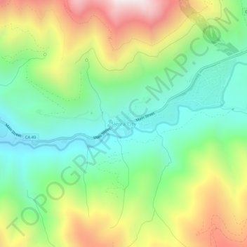
Nome: Mapa topográfico Sierra City, altitude, relevo.
Local: Sierra City, Sierra County, California, United States (39.54555 -120.65600 39.58555 -120.61600)
Altitude média: 1.608 m
Altitude mínima: 1.191 m
Altitude máxima: 2.299 m
Faça uma doação
Outros mapas topográficos
Clique em um mapa para visualizar sua topografia, sua altitude e seu relevo.
Loyalton
United States > California > Sierra County
Loyalton is located at 39°40′36″N 120°14′35″W / 39.67667°N 120.24306°W / 39.67667; -120.24306 (39.676558, -120.243157). Elevation above mean sea level for the area was listed as roughly 4,930 feet (1,500 m). The city is located along California State Route 49, the Gold Country Highway.
Altitude média: 1.514 m