
Faça uma doação
Mapa topográfico Montauroux
Clique no mapa para exibir a altitude.
Faça uma doação
Montauroux
Montauroux is situated in the east of the Var and at the border of the Alpes-Maritimes. Montauroux rises in tiers of altitudes from 150 m to 400 m. The village has a southern exposure, facing the Esterel massif and the St Cassien Lake. Montauroux is located midway between the sea which is 30 km (19 mi) away and the first ski resort which is 40 km (25 mi), away. Montauroux benefits from an exceptional amount of sunny days and is visited by tourists in the summer months, many hotels are often fully booked for the summer by mid-April or earlier.
Faça uma doação
Sobre este mapa
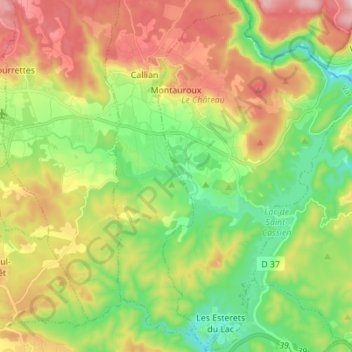
Nome: Mapa topográfico Montauroux, altitude, relevo.
Altitude média: 259 m
Altitude mínima: 81 m
Altitude máxima: 518 m
Faça uma doação
Outros mapas topográficos
Clique em um mapa para visualizar sua topografia, sua altitude e seu relevo.
Faça uma doação
Ruines du Barrage de Malpasset
France > Provence-Alpes-Côte d'Azur > Var > Fréjus
Altitude média: 118 m
Val d'Esquieres
France > Provence-Alpes-Côte d'Azur > Var > Roquebrune-sur-Argens
Altitude média: 82 m
Plage de Bonporteau
France > Provence-Alpes-Côte d'Azur > Var > Cavalaire-sur-Mer
Altitude média: 41 m
Faça uma doação
Faça uma doação
Faça uma doação
Faça uma doação
Les Aires Longues
France > Provence-Alpes-Côte d'Azur > Var > Ginasservis > Les Aires Longues
Altitude média: 411 m
Draguignan
France > Provence-Alpes-Côte d'Azur > Var > Draguignan > Draguignan
The elevation is 200 m. The highest hill near Draguignan is Malmont (551 m). The main river near Draguignan is the Nartuby.
Altitude média: 288 m
Île des Embiez
France > Provence-Alpes-Côte d'Azur > Var > Six-Fours-les-Plages > Le Brusc
Altitude média: 2 m
Faça uma doação
Jospeh Allet
France > Provence-Alpes-Côte d'Azur > Var > Draguignan > Draguignan > Saint François
Altitude média: 207 m
Faça uma doação