
Mapa topográfico Mount Abu
Mapa interativo
Clique no mapa para exibir a altitude.
Sobre este mapa
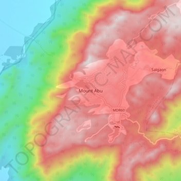
Nome: Mapa topográfico Mount Abu, altitude, relevo.
Altitude média: 914 m
Altitude mínima: 279 m
Altitude máxima: 1.422 m
Mount Abu town, the only hill station in Rajasthan, is at an elevation of 1,220 m (4,003 ft). It has been a popular retreat from the heat of Rajasthan and neighboring Gujarat for centuries.
Outros mapas topográficos
Clique em um mapa para visualizar sua topografia, sua altitude e seu relevo.
Aravalli Range
India > Rajasthan > Abu Road Tehsil
Aravalli Range, Abu Road Tehsil, Sirohi District, Rajasthan, 307501, India
Altitude média: 1.339 m