
Obrigado por apoiar este site ❤️
Faça uma doação
Faça uma doação
Mapa topográfico Tysons
Clique no mapa para exibir a altitude.
Obrigado por apoiar este site ❤️
Faça uma doação
Faça uma doação
Tysons
Tysons is located at 38°55′7″N 77°13′47″W / 38.91861°N 77.22972°W / 38.91861; -77.22972 (38.918485, −77.229833) at an elevation of 486 feet (148 m). Located in Northern Virginia at the intersection of Virginia State Route 123 and State Route 7, Tysons is 11 miles (18 km) west of downtown Washington, D.C. and 6 miles (9.7 km) northeast of Fairfax, the county seat.
Obrigado por apoiar este site ❤️
Faça uma doação
Faça uma doação
Sobre este mapa
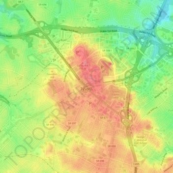
Nome: Mapa topográfico Tysons, altitude, relevo.
Local: Tysons, Fairfax County, Virginia, 22103, United States (38.90340 -77.25444 38.93493 -77.19624)
Altitude média: 123 m
Altitude mínima: 75 m
Altitude máxima: 164 m
Obrigado por apoiar este site ❤️
Faça uma doação
Faça uma doação