Geolocalizar

Mapa topográfico Lympne

Mapa interativo

Clique no mapa para exibir a altitude.

Sobre este mapa

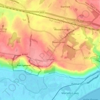
Nome: Mapa topográfico Lympne, altitude, relevo.

Local: Lympne, Folkestone and Hythe District, Kent, England, United Kingdom (51.06661 0.96654 51.09453 1.04742)

Altitude média: 56 m

Altitude mínima: -2 m

Altitude máxima: 113 m

Outros mapas topográficos

Clique em um mapa para visualizar sua topografia, sua altitude e seu relevo.

Hythe

United Kingdom > England > Kent > Folkestone and Hythe District

Hythe, Folkestone and Hythe District, Kent, England, United Kingdom

Altitude média: 32 m

Folkestone

United Kingdom > England > Kent > Folkestone and Hythe District

Folkestone, Folkestone and Hythe District, Kent, England, United Kingdom

Altitude média: 62 m

Park Gate

United Kingdom > England > Kent > Folkestone and Hythe District > Elham

Park Gate, Elham, Folkestone and Hythe District, Kent, England, CT4 6BH, United Kingdom

Altitude média: 130 m

Littlestone on Sea

United Kingdom > England > Kent > Folkestone and Hythe District > New Romney

Littlestone on Sea, New Romney, Folkestone and Hythe District, Kent, England, TN28 8QU, United Kingdom

Altitude média: 1 m

Densole

United Kingdom > England > Kent > Folkestone and Hythe District

Densole, Folkestone and Hythe District, Kent, England, CT18 7BE, United Kingdom

Altitude média: 146 m