
Mapa topográfico Wilmington
Mapa interativo
Clique no mapa para exibir a altitude.
Sobre este mapa
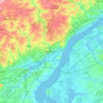
Nome: Mapa topográfico Wilmington, altitude, relevo.
Altitude média: 43 m
Altitude mínima: -5 m
Altitude máxima: 170 m
On the western side of Market Street, the Piedmont topography is rocky and hilly, rising to a point that marks the watershed between the Brandywine River and the Christina River. This watershed line runs along Delaware Avenue westward from 10th Street and Market Street.
Outros mapas topográficos
Clique em um mapa para visualizar sua topografia, sua altitude e seu relevo.
Landlith
United States > Delaware > New Castle County > Wilmington
Landlith, Wilmington, New Castle County, Delaware, 19802, United States
Altitude média: 14 m
Rodney Square
United States > Delaware > New Castle County > Wilmington
Rodney Square, Rodney Square Historic District, Wilmington, New Castle County, Delaware, United States
Altitude média: 20 m
Wawaset Park
United States > Delaware > New Castle County > Wilmington
Wawaset Park, Wilmington, New Castle County, Delaware, 19806, United States
Altitude média: 48 m