
Mapa topográfico Walporzheim
Mapa interativo
Clique no mapa para exibir a altitude.
Sobre este mapa
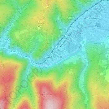
Nome: Mapa topográfico Walporzheim, altitude, relevo.
Altitude média: 219 m
Altitude mínima: 102 m
Altitude máxima: 439 m
Outros mapas topográficos
Clique em um mapa para visualizar sua topografia, sua altitude e seu relevo.
Ahrweiler
Deutschland > Rheinland-Pfalz > Landkreis Ahrweiler > Bad Neuenahr-Ahrweiler > Walporzheim
Ahrweiler, Walporzheim, Bad Neuenahr-Ahrweiler, Landkreis Ahrweiler, Rheinland-Pfalz, 53474, Deutschland
Altitude média: 283 m
Ramersbach
Deutschland > Rheinland-Pfalz > Landkreis Ahrweiler > Bad Neuenahr-Ahrweiler
Ramersbach, Bad Neuenahr-Ahrweiler, Landkreis Ahrweiler, Rheinland-Pfalz, Deutschland
Altitude média: 414 m
Lohrsdorf
Deutschland > Rheinland-Pfalz > Landkreis Ahrweiler > Bad Neuenahr-Ahrweiler
Lohrsdorf, Bad Neuenahr-Ahrweiler, Landkreis Ahrweiler, Rheinland-Pfalz, Deutschland
Altitude média: 141 m
Marienthal
Deutschland > Rheinland-Pfalz > Landkreis Ahrweiler > Bad Neuenahr-Ahrweiler > Marienthal
Marienthal, Bad Neuenahr-Ahrweiler, Landkreis Ahrweiler, Rheinland-Pfalz, Deutschland
Altitude média: 232 m
Neuenahr
Deutschland > Rheinland-Pfalz > Landkreis Ahrweiler > Bad Neuenahr-Ahrweiler
Neuenahr, Bad Neuenahr-Ahrweiler, Landkreis Ahrweiler, Rheinland-Pfalz, Deutschland
Altitude média: 242 m
Neuenahrer Berg
Deutschland > Rheinland-Pfalz > Landkreis Ahrweiler > Bad Neuenahr-Ahrweiler
Neuenahrer Berg, Bad Neuenahr-Ahrweiler, Landkreis Ahrweiler, Rheinland-Pfalz, 53474, Deutschland
Altitude média: 213 m