
Mapa topográfico McKenzie River
Mapa interativo
Clique no mapa para exibir a altitude.
Sobre este mapa
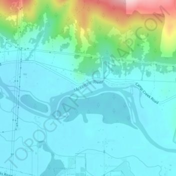
Nome: Mapa topográfico McKenzie River, altitude, relevo.
Altitude média: 190 m
Altitude mínima: 143 m
Altitude máxima: 389 m
The McKenzie River drains a region of about 1,300 square miles (3,400 km2) and is one of the primary tributaries of the Willamette River. Elevations in the watershed range from 10,358 feet (3,157 m) at the summit of the South Sister to 375 feet (114 m) at the McKenzie's mouth on the Willamette River north of Eugene. The upper basin, in the high Cascades, consists of granular, permeable igneous rocks that are geologically young, while most of the middle and lower McKenzie valley in the Western Cascades is made of the remnants of older, more weathered volcanic rocks. Major watersheds bordering the McKenzie basin include the Calapooia; the South, Middle and North Santiam rivers to the north; the Middle Fork Willamette River to the south; and the Deschutes River to the east.
Outros mapas topográficos
Clique em um mapa para visualizar sua topografia, sua altitude e seu relevo.
Redmond
United States of America > Oregon > Redmond
Redmond, Deschutes County, Oregon, 97756, United States of America
Altitude média: 919 m
Tualatin River
United States of America > Oregon
Tualatin River, Clackamas County, Oregon, 97068, United States of America
Altitude média: 82 m
Forfar
United States of America > Oregon > Forfar
Forfar, Lincoln County, Oregon, United States of America
Altitude média: 30 m
Wimer
United States of America > Oregon > Wimer
Wimer, Jackson County, Oregon, United States of America
Altitude média: 417 m
Trask River
United States of America > Oregon
Trask River, Tillamook County, Oregon, 97141, United States of America
Altitude média: 223 m
Springwater
United States of America > Oregon > Springwater
Springwater, Clackamas County, Oregon, 97023, United States of America
Altitude média: 309 m
Millican
United States of America > Oregon > Millican
Millican, Deschutes County, Oregon, United States of America
Altitude média: 1.337 m
Brickerville
United States of America > Oregon > Mapleton > Brickerville
Brickerville, Mapleton, Lane County, Oregon, 97453, United States of America
Altitude média: 183 m
Tillamook Rock Light
United States of America > Oregon
Tillamook Rock Light, Tillamook Rock Lighthouse Trail, Clatsop County, Oregon, United States of America
Altitude média: 0 m
Oak Grove
United States of America > Oregon > Oak Grove
Oak Grove, Clackamas County, Oregon, 97268, United States of America
Altitude média: 49 m
Saum Creek
United States of America > Oregon
Saum Creek, Washington County, Oregon, 97062, United States of America
Altitude média: 110 m
Pilot Rock
United States of America > Oregon > Pilot Rock
Pilot Rock, Umatilla County, Oregon, United States of America
Altitude média: 527 m
Hail Creek
United States of America > Oregon
Hail Creek, Crook County, Oregon, United States of America
Altitude média: 1.412 m
Thousand Springs
United States of America > Oregon
Thousand Springs, Thousand Springs Road, Jackson County, Oregon, United States of America
Altitude média: 1.536 m
Saint Joseph
United States of America > Oregon > Saint Joseph
Saint Joseph, Yamhill County, Oregon, 97127, United States of America
Altitude média: 44 m
Jones Creek
United States of America > Oregon
Jones Creek, Josephine County, Oregon, 97506, United States of America
Altitude média: 333 m