
Faça uma doação
Mapa topográfico Eckert
Clique no mapa para exibir a altitude.
Faça uma doação
Sobre este mapa
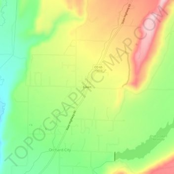
Nome: Mapa topográfico Eckert, altitude, relevo.
Local: Eckert, Delta County, Colorado, 81418, United States (38.82276 -107.98284 38.86276 -107.94284)
Altitude média: 1.691 m
Altitude mínima: 1.585 m
Altitude máxima: 1.817 m
Faça uma doação
Outros mapas topográficos
Clique em um mapa para visualizar sua topografia, sua altitude e seu relevo.
Cedaredge
United States > Colorado > Delta County
Located in a protected valley at 6,100 feet (1,900 m) in elevation, the Cedaredge Golf Club course has natural cedars and winding creek beds.
Altitude média: 1.883 m
Faça uma doação
Cedaredge
United States > Colorado > Delta County
Located in a protected valley at 6,100 feet (1,900 m) in elevation, the Cedaredge Golf Club course has natural cedars and winding creek beds.
Altitude média: 1.883 m
Cedaredge
United States > Colorado > Delta County
Located in a protected valley at 6,100 feet (1,900 m) in elevation, the Cedaredge Golf Club course has natural cedars and winding creek beds.
Altitude média: 1.883 m
Cedaredge
United States > Colorado > Delta County
Located in a protected valley at 6,100 feet (1,900 m) in elevation, the Cedaredge Golf Club course has natural cedars and winding creek beds.
Altitude média: 1.883 m
Faça uma doação