
Mapa topográfico Castel Gandolfo
Mapa interativo
Clique no mapa para exibir a altitude.
Castel Gandolfo
The maximum elevation registered in the territory is 425 metres (1,394 ft) above sea level, at the Collegio di Propaganda Fide adjoining Villa Barberini. On the crown of the hills around the Lake Albano, the elevation is only 400 metres (1,300 ft) above sea level, at the summit of Monte Cucco, bordering Marino.
Sobre este mapa
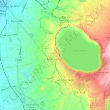
Nome: Mapa topográfico Castel Gandolfo, altitude, relevo.
Local: Castel Gandolfo, Roma Capitale, 00073, Italy (41.72476 12.59258 41.76520 12.68832)
Altitude média: 306 m
Altitude mínima: 131 m
Altitude máxima: 633 m