
Mapa topográfico Illmensee
Mapa interativo
Clique no mapa para exibir a altitude.
Sobre este mapa
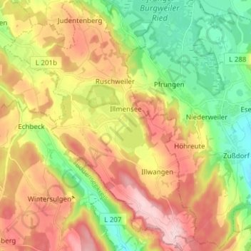
Nome: Mapa topográfico Illmensee, altitude, relevo.
Altitude média: 698 m
Altitude mínima: 577 m
Altitude máxima: 839 m
The municipality (Gemeinde) of Illmensee is situated at the southeastern corner of the district of Sigmaringen, in the German state of Baden-Württemberg. Illmensee lies along Sigmaringen's border with the district of Ravensburg to the east and the Bodensee district to the south. The municipality is physically located in a depression formed by the Würm glaciation in the Upper Swabian hill country [de]. The municipality's three lakes, the Illmensee itself, Ruschweiler [de], and the Volzer [de] lakes, are glacial lakes that were also formed by the Würm glaciation. Elevation above sea level in the municipal area ranges from a high of 833 meters (2,733 ft) Normalnull (NN) to a low of 667 meters (2,188 ft) NN.
Outros mapas topográficos
Clique em um mapa para visualizar sua topografia, sua altitude e seu relevo.
Schnerkingen
Germany > Baden-Württemberg > Landkreis Sigmaringen > Meßkirch
Schnerkingen, Meßkirch, Verwaltungsgemeinschaft Meßkirch, Landkreis Sigmaringen, Baden-Württemberg, 88605, Germany
Altitude média: 634 m
Sigmaringen
Germany > Baden-Württemberg > Landkreis Sigmaringen
Sigmaringen, Gemeindeverwaltungsverband Sigmaringen, Landkreis Sigmaringen, Baden-Württemberg, 72488, Germany
Altitude média: 655 m
Pfullendorf
Germany > Baden-Württemberg > Landkreis Sigmaringen
Pfullendorf, Verwaltungsgemeinschaft Pfullendorf, Landkreis Sigmaringen, Baden-Württemberg, 88630, Germany
Altitude média: 654 m