
Faça uma doação
Mapa topográfico Fitful Head
Clique no mapa para exibir a altitude.
Faça uma doação
Sobre este mapa
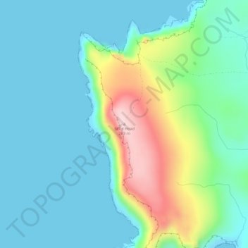
Nome: Mapa topográfico Fitful Head, altitude, relevo.
Local: Fitful Head, Shetland, Scotland, United Kingdom (59.90576 -1.38225 59.90586 -1.38215)
Altitude média: 68 m
Altitude mínima: 0 m
Altitude máxima: 284 m
Faça uma doação
Outros mapas topográficos
Clique em um mapa para visualizar sua topografia, sua altitude e seu relevo.
Lerwick
United Kingdom > Scotland > Shetland
Lerwick has transitioned from a subpolar oceanic climate (Cfc) to a maritime climate (Cfb) with cool to cold temperatures all year long. The lack of trees reflects the latter type. This is particularly pronounced by virtue of Lerwick being on the coast of an island, so even extreme temperature records are…
Altitude média: 34 m
Faça uma doação
Yell
United Kingdom > Scotland > Shetland
Yell is 19 miles (31 kilometres) in length, with a maximum breadth of 7.5 miles (12.1 kilometres), and is swept all around by very impetuous tides. The island extends northward to within 9.5 miles (15.3 kilometres) of the northwestern extremity of Unst. It is divided by only the narrow Bluemull Sound from the…
Altitude média: 27 m
Faça uma doação
Out Skerries
United Kingdom > Scotland > Shetland
Being so close to Norway, the islands were of strategic importance in World War II and were a regular landfall for Norwegian boats carrying escapees from the Nazi occupation. The local coastguard was responsible for the refugees, and at one point during the war were issued with a tommy gun, although initially…
Altitude média: 1 m
Faça uma doação
Faça uma doação
Housay
United Kingdom > Scotland > Shetland
Being so close to Norway, the islands were of strategic importance in World War II and were a regular landfall for Norwegian boats carrying escapees from the Nazi occupation. The local coastguard was responsible for the refugees, and at one point during the war were issued with a tommy gun, although initially…
Altitude média: 3 m
Faça uma doação