
Mapa topográfico Brussels–Scheldt Maritime Canal
Mapa interativo
Clique no mapa para exibir a altitude.
Sobre este mapa
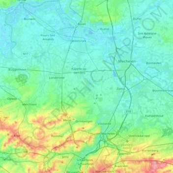
Nome: Mapa topográfico Brussels–Scheldt Maritime Canal, altitude, relevo.
Altitude média: 22 m
Altitude mínima: -3 m
Altitude máxima: 110 m
The difference in altitude of 14 m between Brussels and the Rupel river at Willebroek was achieved with 4 locks. With the commissioning of the canal, the ships could now avoid navigating the Zenne and being subject to tax in Mechelen.
Outros mapas topográficos
Clique em um mapa para visualizar sua topografia, sua altitude e seu relevo.
Woluwe
Belgium > Flemish Brabant > Brussels-Capital > Brussels
Woluwe, Brussels, City of Brussels, Brussels-Capital, Flemish Brabant, Brussels-Capital, 1831, Belgium
Altitude média: 64 m