
Mapa topográfico The Borough District of Drogheda
Mapa interativo
Clique no mapa para exibir a altitude.
Sobre este mapa
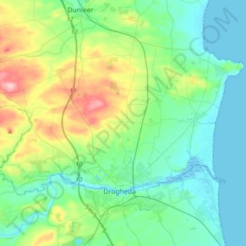
Nome: Mapa topográfico The Borough District of Drogheda, altitude, relevo.
Altitude média: 50 m
Altitude mínima: -1 m
Altitude máxima: 209 m
Outros mapas topográficos
Clique em um mapa para visualizar sua topografia, sua altitude e seu relevo.
Plaster
Plaster, Ballymascanlan ED, The Municipal District of Dundalk, County Louth, Leinster, Irlanda
Altitude média: 55 m