
Mapa topográfico Alston
Clique no mapa para exibir a altitude.
Alston
Alston is a town in Cumbria, England, within the civil parish of Alston Moor on the River South Tyne. It shares the title of the 'highest market town in England', at about 1,000 feet (300 m) above sea level, with Buxton, Derbyshire. Despite its altitude, the town is easily accessible via the many roads which link the town to Weardale, Teesdale, and towns in Cumbria such as Penrith via Hartside Pass, as well as Tynedale. Historically part of Cumberland, Alston lies within the North Pennines, a designated Area of Outstanding Natural Beauty. Much of the town centre is a designated Conservation Area which includes several listed buildings.
Sobre este mapa
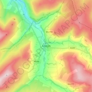
Nome: Mapa topográfico Alston, altitude, relevo.
Altitude média: 404 m
Altitude mínima: 218 m
Altitude máxima: 598 m
Outros mapas topográficos
Clique em um mapa para visualizar sua topografia, sua altitude e seu relevo.
Mallerstang Edge
United Kingdom > England > Westmorland and Furness > Mallerstang
Altitude média: 489 m
Trout Beck
United Kingdom > England > Westmorland and Furness > Troutbeck Bridge
Altitude média: 308 m
Howgill Fells
United Kingdom > England > Westmorland and Furness > Ravenstonedale
Altitude média: 303 m
Wharton Tarn
United Kingdom > England > Westmorland and Furness > Hawkshead > Hawkshead Hill
Altitude média: 173 m
River Lune
United Kingdom > England > Westmorland and Furness
The river begins as a stream at Newbiggin, in the parish of Ravenstonedale, Cumbria, at St. Helen's Well (elevation of 238 metres (781 ft) above sea level) and some neighbouring springs. On the first two miles of its course, it is joined by four streams, two of them as short as itself, but two much longer.…
Altitude média: 220 m
Dufton
United Kingdom > England > Westmorland and Furness
Dufton Ghyll Wood is an area of semi-natural ancient woodland that contains significant outcrops of St Bees Sandstone. Other local geographic features include Dufton Pike, Knock Pike, Cross Fell and High Cup. The locality is also known for the Helm Wind and Helm Bar. The latter are wind and cloud effects…
Altitude média: 387 m
Deepdale Beck
United Kingdom > England > Westmorland and Furness > South Lakeland > Dent
Altitude média: 280 m
Roudsea Wood
United Kingdom > England > Westmorland and Furness > South Lakeland > Haverthwaite
Altitude média: 7 m
Scout Scar
United Kingdom > England > Westmorland and Furness > Brigsteer
Scout Scar, also called Underbarrow Scar, is a hill in the English Lake District, west of Kendal, Cumbria and above the village of Underbarrow. It reaches 771 feet (235 m). Scout Scar is the subject of a chapter of Wainwright's book The Outlying Fells of Lakeland, but the summit he describes is a lower summit…
Altitude média: 130 m
River Glenderamackin
United Kingdom > England > Westmorland and Furness > Threlkeld
Altitude média: 346 m
Three Dubs Tarn
United Kingdom > England > Westmorland and Furness > Bowness-on-Windermere
Altitude média: 156 m