
Mapa topográfico Whitley City
Mapa interativo
Clique no mapa para exibir a altitude.
Sobre este mapa
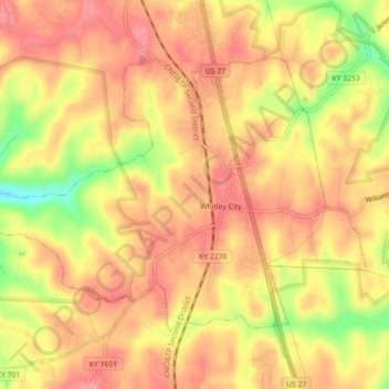
Nome: Mapa topográfico Whitley City, altitude, relevo.
Altitude média: 390 m
Altitude mínima: 328 m
Altitude máxima: 420 m
Outros mapas topográficos
Clique em um mapa para visualizar sua topografia, sua altitude e seu relevo.
Stearns
United States > Kentucky > McCreary County
Stearns, McCreary County, Kentucky, United States
Altitude média: 392 m
Yamacraw
United States > Kentucky > McCreary County
Yamacraw, McCreary County, Kentucky, 42647, United States
Altitude média: 315 m
Flat Rock
United States > Kentucky > McCreary County
Flat Rock, McCreary County, Kentucky, 42653, United States
Altitude média: 374 m
Bell Farm
United States > Kentucky > McCreary County
Bell Farm, McCreary County, Kentucky, United States
Altitude média: 369 m
Strunk
United States > Kentucky > McCreary County > Strunk
Strunk, McCreary County, Kentucky, 42649, United States
Altitude média: 410 m
Pine Knot
United States > Kentucky > McCreary County
Pine Knot, McCreary County, Kentucky, United States
Altitude média: 399 m