
Faça uma doação
Mapa topográfico Danethorpe Hill
Clique no mapa para exibir a altitude.
Faça uma doação
Sobre este mapa
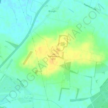
Nome: Mapa topográfico Danethorpe Hill, altitude, relevo.
Altitude média: 22 m
Altitude mínima: 12 m
Altitude máxima: 38 m
Faça uma doação
Outros mapas topográficos
Clique em um mapa para visualizar sua topografia, sua altitude e seu relevo.
Newark
United Kingdom > England > Nottinghamshire > Newark and Sherwood > Newark on Trent
Altitude média: 17 m
Faça uma doação
Sherwood Forest NNR
United Kingdom > England > Nottinghamshire > Newark and Sherwood > Ollerton > Edwinstowe CP
Altitude média: 71 m
Faça uma doação
Balderton
United Kingdom > England > Nottinghamshire > Newark and Sherwood > Balderton
Altitude média: 20 m
Faça uma doação
Staythorpe CP
United Kingdom > England > Nottinghamshire > Newark and Sherwood
The land is very low-lying and level, varying little in elevation between 12–14 metres (39–46 ft) throughout.
Altitude média: 16 m
Faça uma doação
Kelham CP
United Kingdom > England > Nottinghamshire > Newark and Sherwood > Newark on Trent
Altitude média: 23 m
Faça uma doação
Faça uma doação
Sherwood Forest National Nature Reserve
United Kingdom > England > Nottinghamshire > Newark and Sherwood > Ollerton
Altitude média: 71 m
Faça uma doação
North Muskham CP
United Kingdom > England > Nottinghamshire > Newark and Sherwood
Altitude média: 11 m
Faça uma doação
Gunthorpe
United Kingdom > England > Nottinghamshire > Newark and Sherwood > Gunthorpe
Altitude média: 23 m
Vicar Water Country Park
United Kingdom > England > Nottinghamshire > Newark and Sherwood > Clipstone
Altitude média: 97 m
Faça uma doação
Faça uma doação
Hoveringham
United Kingdom > England > Nottinghamshire > Newark and Sherwood > Hoveringham
Altitude média: 30 m
Spalford Warren
United Kingdom > England > Nottinghamshire > Newark and Sherwood > Spalford
Altitude média: 7 m
Faça uma doação
Epperstone CP
United Kingdom > England > Nottinghamshire > Newark and Sherwood
The report notes Epperstone's "very distinctive character... a combination of topography, buildings, trees and walls.... The constantly changing views make it an attractive space to move through." It also notes, "The approach to the village from the west is along a tunnel formed by overhanging trees, including…
Altitude média: 69 m
Faça uma doação
Carlton-on-Trent CP
United Kingdom > England > Nottinghamshire > Newark and Sherwood
Altitude média: 12 m
Sutton-on-Trent CP
United Kingdom > England > Nottinghamshire > Newark and Sherwood
Altitude média: 13 m
Faça uma doação
Sherwood Forest NNR
United Kingdom > England > Nottinghamshire > Newark and Sherwood > Ollerton
Altitude média: 71 m
Hoveringham
United Kingdom > England > Nottinghamshire > Newark and Sherwood > Hoveringham
Altitude média: 30 m
Faça uma doação
Newark
United Kingdom > England > Nottinghamshire > Newark and Sherwood > Newark on Trent
Altitude média: 17 m