
Faça uma doação
Mapa topográfico Lake San Cristobal
Clique no mapa para exibir a altitude.
Faça uma doação
Lake San Cristobal
Lake San Cristobal is a lake in the U.S. state of Colorado. Located in the San Juan Mountains at an elevation of 9,003 feet (2,744 m), the freshwater lake is 2.1 miles (3.4 km) long, up to 89 feet (27 m) deep, has a surface area of 0.52 square miles (1.3 km2), and holds about 11,000 acre-feet (14,000,000 m3) of water. The town of Lake City, a few miles to the north, is named after Lake San Cristobal. The name San Cristóbal means Saint Christopher in the Spanish language. Many old silver mines are near the lake and it is very clean and well kept, and stocked with Rainbow Trout.
Faça uma doação
Sobre este mapa
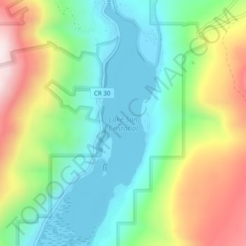
Nome: Mapa topográfico Lake San Cristobal, altitude, relevo.
Altitude média: 2.947 m
Altitude mínima: 2.744 m
Altitude máxima: 3.326 m
Faça uma doação
Outros mapas topográficos
Clique em um mapa para visualizar sua topografia, sua altitude e seu relevo.