
Mapa topográfico Union Canal
Mapa interativo
Clique no mapa para exibir a altitude.
Sobre este mapa
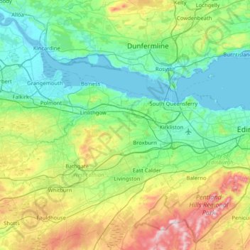
Nome: Mapa topográfico Union Canal, altitude, relevo.
Local: Union Canal, West Lothian, Schotland, EH11 1AS, VK (55.91628 -3.84183 56.00172 -3.20835)
Altitude média: 136 m
Altitude mínima: -3 m
Altitude máxima: 564 m
Outros mapas topográficos
Clique em um mapa para visualizar sua topografia, sua altitude e seu relevo.
Fort William
VK > Schotland > Fort William
Fort William, Highland, Schotland, PH33 6DH, VK
Altitude média: 122 m
Forth and Clyde Canal
Forth and Clyde Canal, East Dunbartonshire, Schotland, G81 1QA, VK
Altitude média: 130 m
Caledonian Canal
Caledonian Canal, Highland, Schotland, IV3 8RE, VK
Altitude média: 420 m
Linga
VK > Schotland > South Garth
Linga, South Garth, Shetland Islands, Schotland, VK
Altitude média: 7 m
Greenbraehead
VK > Schotland > Greenbraehead
Greenbraehead, Scottish Borders, Schotland, TD9 9SW, VK
Altitude média: 187 m