
Mapa topográfico Shopian
Clique no mapa para exibir a altitude.
Sobre este mapa
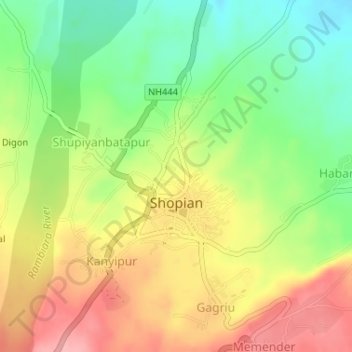
Nome: Mapa topográfico Shopian, altitude, relevo.
Local: Shopian, Shopian District, Jammu and Kashmir, India (33.71300 74.82253 33.72867 74.84543)
Altitude média: 2.033 m
Altitude mínima: 1.976 m
Altitude máxima: 2.092 m
Outros mapas topográficos
Clique em um mapa para visualizar sua topografia, sua altitude e seu relevo.
Katra
India > Jammu and Kashmir > Reasi
Katra is located at 32°59′N 74°57′E / 32.98°N 74.95°E / 32.98; 74.95. It has an average elevation of 875 metres (2,474 feet). The Banganga River passes through the village.
Altitude média: 993 m
Amarnath Cave Temple
India > Jammu and Kashmir > Pahalgam
The Shiva Lingam at the shrine is a Swayambhu lingam. The lingam is a natural stalagmite formation located at the Amarnath Mountain which has a peak of 5,186 metres (17,014 ft), and inside a 40 m (130 ft) high cave at an elevation of 3,888 m (12,756 ft). The stalagmite is formed due to the freezing of water…
Altitude média: 4.325 m
Anantnag district
"Sir Walter Lawrence writes in his book The Valley of Kashmir that in latitude Kashmir corresponds with Peshawar, Baghdad and Damascus in Asia: with Fez in Morocco: and South Carolina in America, but it presents none of the characteristics of those countries. People have linked the climate of Kashmir to that…
Altitude média: 2.830 m
Rajouri
India > Jammu and Kashmir > Rajauri
Rajouri is located at 33°23′N 74°18′E / 33.38°N 74.3°E / 33.38; 74.3. It has an average elevation of 915 metres (3001 feet).
Altitude média: 1.038 m
Khrew
India > Jammu and Kashmir > Pampore
Khrew is located at 34°01′12″N 74°59′24″E / 34.020°N 74.99°E / 34.020; 74.99. It has an average elevation of 1,607 metres (5,272 feet) and is located in the Kashmir valley. The area starts from Babapora to Seer Bagh and from Bathen to Androosa. Also, the foot region is extended to Ladhoo,…
Altitude média: 1.788 m
Kathua
India > Jammu and Kashmir > Kathua
Kathua is located at 32°22′N 75°31′E / 32.37°N 75.52°E / 32.37; 75.52. It has an average elevation of 393 metres (1,289 ft). The city is surrounded by three rivers. Ravi is 7 km (4.3 mi) down Kathua while Ujjh is about 11 km (6.8 mi) ahead on Jammu Highway. Kathua itself is situated along the…
Altitude média: 411 m