
Mapa topográfico Bothamsall
Clique no mapa para exibir a altitude.
Sobre este mapa
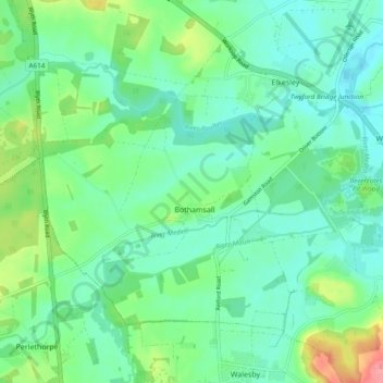
Nome: Mapa topográfico Bothamsall, altitude, relevo.
Altitude média: 37 m
Altitude mínima: 15 m
Altitude máxima: 97 m
Outros mapas topográficos
Clique em um mapa para visualizar sua topografia, sua altitude e seu relevo.
Retford
United Kingdom > England > Nottinghamshire > Bassetlaw
In 1831, the Gas Works was built by James Malam and gaslights were lit in the town for the first time on 22 December 1831. The Square was lit by a cast iron light bearing five gas lamps at that time. The Gas Works became a target on 2 September 1916 when a German Zeppelin dropped 14 bombs on Retford. The…
Altitude média: 31 m
Skegby
United Kingdom > England > Nottinghamshire > Bassetlaw > Normanton on Trent
Altitude média: 18 m
Mattersey Thorpe
United Kingdom > England > Nottinghamshire > Bassetlaw > Mattersey
Altitude média: 12 m
Littleborough
United Kingdom > England > Nottinghamshire > Bassetlaw > Littleborough
Altitude média: 10 m
Walkeringham
United Kingdom > England > Nottinghamshire > Bassetlaw > Walkeringham
Altitude média: 16 m
North Leverton with Habblesthorpe
United Kingdom > England > Nottinghamshire > Bassetlaw
Altitude média: 20 m
South Leverton
United Kingdom > England > Nottinghamshire > Bassetlaw > South Leverton
Altitude média: 22 m