
Mapa topográfico Chiloquin
Mapa interativo
Clique no mapa para exibir a altitude.
Sobre este mapa
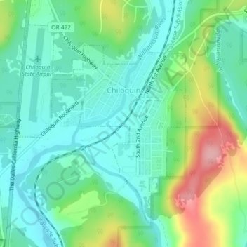
Nome: Mapa topográfico Chiloquin, altitude, relevo.
Local: Chiloquin, Klamath County, Oregon, United States (42.56307 -121.88208 42.58478 -121.85693)
Altitude média: 1.302 m
Altitude mínima: 1.262 m
Altitude máxima: 1.395 m
Chiloquin is at an elevation of 4,180 feet (1,270 m) in Klamath County. The city is slightly east of U.S. Route 97 and slightly north of its intersection with Oregon Route 62. A short east–west highway, Oregon Route 422, links Route 97 at Chiloquin to Route 62 slightly south of Klamath Agency. By highway, Chiloquin is about 26 miles (42 km) north of Klamath Falls and 253 miles (407 km) south of Portland.
Outros mapas topográficos
Clique em um mapa para visualizar sua topografia, sua altitude e seu relevo.
Deepest point -592m
United States > Oregon > Klamath County
Deepest point -592m, Klamath County, Oregon, United States
Altitude média: 1.880 m
Link River
United States > Oregon > Klamath County > Klamath Falls
Link River, Klamath Falls, Klamath County, Oregon, United States
Altitude média: 1.304 m
Crater Lake
United States > Oregon > Klamath County
Crater Lake, Klamath County, Oregon, United States
Altitude média: 1.971 m
Willamette Pass
United States > Oregon > Klamath County
Willamette Pass, Klamath County, Oregon, United States
Altitude média: 1.605 m
Crater Lake National Park
United States > Oregon > Klamath County
Crater Lake National Park, Klamath County, Oregon, 97604, United States
Altitude média: 1.726 m
Klamath Falls
United States > Oregon > Klamath County
Klamath Falls, Klamath County, Oregon, 97601, United States
Altitude média: 1.312 m