
Mapa topográfico Burrow
Mapa interativo
Clique no mapa para exibir a altitude.
Sobre este mapa
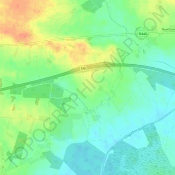
Nome: Mapa topográfico Burrow, altitude, relevo.
Altitude média: 64 m
Altitude mínima: 48 m
Altitude máxima: 88 m
Outros mapas topográficos
Clique em um mapa para visualizar sua topografia, sua altitude e seu relevo.
Mount Lucas
Mount Lucas, Esker ED, The Municipal District of Edenderry, County Offaly, Leinster, R35 XW10, Ireland
Altitude média: 76 m
Hamilton's Lock
Hamilton's Lock, Lusmagh ED, The Municipal District of Birr, County Offaly, Leinster, Ireland
Altitude média: 35 m
Ballintogher
Ballintogher, Rathfeston ED, The Municipal District of Edenderry, County Offaly, Leinster, Ireland
Altitude média: 86 m
Coleraine
Coleraine, Silverbrook ED, The Municipal District of Tullamore, County Offaly, Leinster, Ireland
Altitude média: 59 m
Edenderry
Edenderry, The Municipal District of Edenderry, County Offaly, Leinster, Ireland
Altitude média: 74 m
The Municipal District of Birr
The Municipal District of Birr, County Offaly, Leinster, Ireland
Altitude média: 97 m
The Municipal District of Edenderry
The Municipal District of Edenderry, County Offaly, Leinster, Ireland
Altitude média: 80 m
Kinnity
Ireland > County Offaly > The Municipal District of Birr
Kinnity, The Municipal District of Birr, County Offaly, Leinster, Ireland
Altitude média: 251 m
Tullamore
Tullamore, Tullamore Urban ED, The Municipal District of Tullamore, County Offaly, Leinster, R35 P761, Ireland
Altitude média: 63 m
Carrig Bridge
Ireland > County Offaly > The Municipal District of Birr
Carrig Bridge, Seirkieran ED, The Municipal District of Birr, County Offaly, Leinster, R42 W542, Ireland
Altitude média: 84 m
Shinrone
Ireland > County Offaly > The Municipal District of Birr > Shinrone
Shinrone, The Municipal District of Birr, County Offaly, Leinster, Ireland
Altitude média: 72 m
Road
Road, Ballyburly ED, The Municipal District of Edenderry, County Offaly, Leinster, Ireland
Altitude média: 87 m
Banagher
Ireland > County Offaly > Banagher
Banagher, The Municipal District of Birr, County Offaly, Leinster, R42 DE61, Ireland
Altitude média: 43 m
Daingean
Ireland > County Offaly > Daingean
Daingean, The Municipal District of Edenderry, County Offaly, Leinster, Ireland
Altitude média: 82 m
Down
Down, Clonygowan ED, The Municipal District of Edenderry, County Offaly, Leinster, Ireland
Altitude média: 88 m