
Mapa topográfico Rheinbrohl
Mapa interativo
Clique no mapa para exibir a altitude.
Sobre este mapa
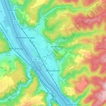
Nome: Mapa topográfico Rheinbrohl, altitude, relevo.
Altitude média: 164 m
Altitude mínima: 52 m
Altitude máxima: 359 m
Zur Gemeinde Rheinbrohl gehören der Ortsteil Arienheller sowie die Wohnplätze Annahof, Berghof, Christinenhöhe, Dielsberg, Hartmannshof, Haus Bergfriede, Haus Forst, Jagdhaus Wilhelmsruh, Lampenthalerhof, Magdalenenhof und Zur alten Mühle.
Outros mapas topográficos
Clique em um mapa para visualizar sua topografia, sua altitude e seu relevo.
Jungeroth
Deutschland > Rheinland-Pfalz > Landkreis Neuwied
Jungeroth, Buchholz (Westerwald), Asbach, Landkreis Neuwied, Rheinland-Pfalz, 53567, Deutschland
Altitude média: 236 m