
Mapa topográfico Linvale
Mapa interativo
Clique no mapa para exibir a altitude.
Sobre este mapa
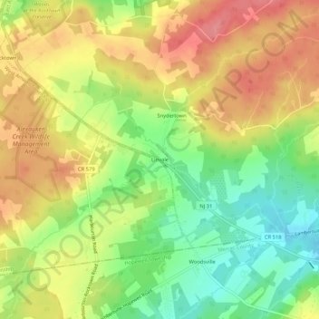
Nome: Mapa topográfico Linvale, altitude, relevo.
Altitude média: 109 m
Altitude mínima: 62 m
Altitude máxima: 152 m
Outros mapas topográficos
Clique em um mapa para visualizar sua topografia, sua altitude e seu relevo.
Bowne
United States > New Jersey > Hunterdon County > East Amwell Township
Bowne, East Amwell Township, Hunterdon County, New Jersey, United States
Altitude média: 74 m
Larisons Corners
United States > New Jersey > Hunterdon County > East Amwell Township
Larisons Corners, East Amwell Township, Hunterdon County, New Jersey, 08551, United States
Altitude média: 66 m
Snydertown
United States > New Jersey > Hunterdon County > East Amwell Township
Snydertown, East Amwell Township, Hunterdon County, New Jersey, 08551, United States
Altitude média: 110 m
Wertsville
United States > New Jersey > Hunterdon County > East Amwell Township
Wertsville, East Amwell Township, Hunterdon County, New Jersey, United States
Altitude média: 72 m
Ringoes
United States > New Jersey > Hunterdon County > East Amwell Township
Ringoes, East Amwell Township, Hunterdon County, New Jersey, 08551, United States
Altitude média: 75 m
Rileyville
United States > New Jersey > Hunterdon County > East Amwell Township
Rileyville, East Amwell Township, Hunterdon County, New Jersey, 08525, United States
Altitude média: 125 m