
Faça uma doação
Mapa topográfico Mableton
Clique no mapa para exibir a altitude.
Faça uma doação
Sobre este mapa
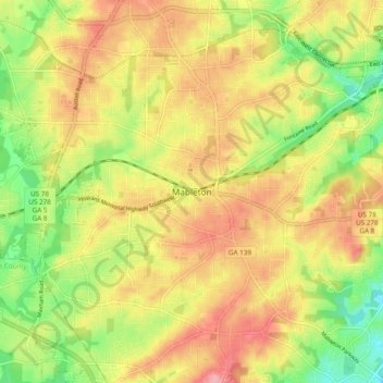
Nome: Mapa topográfico Mableton, altitude, relevo.
Local: Mableton, Cobb County, Georgia, 30168, United States (33.77883 -84.62226 33.85883 -84.54226)
Altitude média: 298 m
Altitude mínima: 234 m
Altitude máxima: 356 m
Faça uma doação
Outros mapas topográficos
Clique em um mapa para visualizar sua topografia, sua altitude e seu relevo.
Kennesaw
United States > Georgia > Cobb County
Kennesaw is located in northwestern Cobb County, bordered by the city of Acworth to the northwest. Kennesaw Mountain is located southeast of the city limits in the battlefield park. Its summit is the highest point in the Atlanta metro area, at an elevation of 1,808 feet (551 m) above sea level. The city was…
Altitude média: 317 m
Faça uma doação
Faça uma doação
Faça uma doação
Faça uma doação
Kennesaw
United States > Georgia > Cobb County
Kennesaw is located in northwestern Cobb County, bordered by the city of Acworth to the northwest. Kennesaw Mountain is located southeast of the city limits in the battlefield park. Its summit is the highest point in the Atlanta metro area, at an elevation of 1,808 feet (551 m) above sea level. The city was…
Altitude média: 317 m
Faça uma doação