
Faça uma doação
Mapa topográfico Spring Hill
Clique no mapa para exibir a altitude.
Faça uma doação
Sobre este mapa
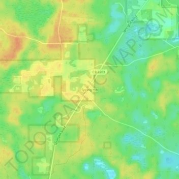
Nome: Mapa topográfico Spring Hill, altitude, relevo.
Local: Spring Hill, Leon County, Florida, United States (30.31937 -84.40796 30.35937 -84.36796)
Altitude média: 23 m
Altitude mínima: 4 m
Altitude máxima: 39 m
Faça uma doação
Outros mapas topográficos
Clique em um mapa para visualizar sua topografia, sua altitude e seu relevo.
Tallahassee
United States > Florida > Leon County
Tallahassee's terrain is hilly by Florida standards, being at the southern end of the Red Hills Region, just above the Cody Scarp. The elevation varies from near sea level to just over 200 feet (61 m), with the state capitol on one of the highest hills in the city. The city includes two large lake basins, Lake…
Altitude média: 36 m
Alfred B. Maclay Gardens State Park
United States > Florida > Leon County > Tallahassee
Altitude média: 58 m