
Faça uma doação
Mapa topográfico Spézet
Clique no mapa para exibir a altitude.
Faça uma doação
Spézet
Spézet is a rural municipality in east central Finistère, historically belonging to Cornouaille. It is bounded on the west and north by the river the Aulne and Hyères describing large meanders (Nantes-Brest Canal-channel) while at the southeast end of its territory lies Roc'h Toullaëron, which from its height of 318 m is the culmination of the Black Mountains. The village occupies a small hill whose altitude is around 100 meters northwest of the town. Spézet is border by Saint-Hernin to the east, by Gourin to the southeast, by Roudouallec to the south, by Saint-Goazec to the southwest, by Châteauneuf-du-Faou to the west and by Plonévez-du-Faou, Landeleau and Cleden-Poher to the north.
Faça uma doação
Sobre este mapa
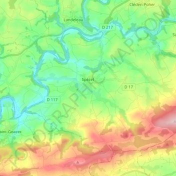
Nome: Mapa topográfico Spézet, altitude, relevo.
Altitude média: 136 m
Altitude mínima: 40 m
Altitude máxima: 310 m
Faça uma doação
Outros mapas topográficos
Clique em um mapa para visualizar sua topografia, sua altitude e seu relevo.
Faça uma doação
Faça uma doação
Faça uma doação
Faça uma doação
Faça uma doação
Faça uma doação
Manoir de Cœcilian (Saint-Pol-Roux)
France > Brittany > Finistère > Camaret-sur-Mer
Altitude média: 17 m
Faça uma doação
Faça uma doação
Faça uma doação
Faça uma doação
Faça uma doação
Faça uma doação