
Faça uma doação
Mapa topográfico Royton
Clique no mapa para exibir a altitude.
Faça uma doação
Royton
Described in Samuel Lewis's A Topographical Dictionary of England (1848) as being in "aspect rather wild", Royton lies in a shallow valley amongst undulating land. The sources of the rivers Irk and Beal are to the northeast and east respectively. The Irk meanders southwesterly into Chadderton, and then onwards to Middleton into Manchester before uniting its waters with the River Irwell in Manchester city centre. The general slope of the land decreases in height away from the Pennines, from east to west, but reaches high points of 509 feet (155 m) at Tandle Hill and 825 feet (251 m) at the summit of Oldham Edge, a ridge of elevated land which leads to Oldham. The soils of the town are broadly sand with subsoils of clay.
Faça uma doação
Sobre este mapa
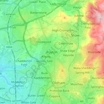
Nome: Mapa topográfico Royton, altitude, relevo.
Altitude média: 181 m
Altitude mínima: 86 m
Altitude máxima: 393 m
Faça uma doação
Outros mapas topográficos
Clique em um mapa para visualizar sua topografia, sua altitude e seu relevo.
Sheffield
Sheffield nestles on the eastern foothills of the Pennines and is sculpted by a dramatic hill-and-valley system formed where five rivers — the Don, Sheaf, Rivelin, Loxley and Porter — converge, producing steep-sided valleys and gritstone ridgelines with much of the urban area built directly onto hillsides…
Altitude média: 168 m
South East England
Near Weybridge are the UK headquarters of Sony with SSP Group (situated in Byfleet) and Procter & Gamble (next door to each other on The Heights Business Park near the former Brooklands racing circuit) with Kia Motors UK and Petroleum Geo-Services UK, and Gallaher Group (cigarettes) is to the north, next to…
Altitude média: 69 m
Faça uma doação
Birmingham
Birmingham is a snowy city relative to other large UK conurbations, due to its inland location and comparatively high elevation. Between 1961 and 1990 Birmingham Airport averaged 13.0 days of snow lying annually, compared to 5.33 at London Heathrow. Snow showers often pass through the city via the Cheshire gap…
Altitude média: 138 m
Kent
Kent was also the location of the largest number of art schools in the country during the nineteenth century, estimated by the art historian David Haste, to approach two hundred. This is believed to be the result of Kent being a front line county during the Napoleonic Wars. At this time, before the invention…
Altitude média: 37 m
Isle of Portland
United Kingdom > England > Dorset > Wyke Regis
In Museums Without Walls, Jonathan Meades declares that "Portland is a bulky chunk of geological, social, topographical and demographic weirdness. It is the obverse of a beauty spot. 'Beauty' in this construction implies the picturesque. Portland is gloriously bereft of this quality. It is awesome. There is…
Altitude média: 11 m
Faça uma doação
Greater London
London's topography is characterized by a gently rolling terrain shaped by the River Thames and its tributaries. The city lies within the London Basin, a natural depression bordered by higher grounds such as the North Downs to the south and the Chiltern Hills to the northwest. The Thames flows west to east,…
Altitude média: 66 m
East of England
The East of England region has the lowest elevation range in the UK. Twenty percent of the region is below mean sea level, most of this in North Cambridgeshire, Norfolk and on the Essex Coast. Most of the remaining area is of low elevation, with extensive glacial deposits. The Fens, a large area of reclaimed…
Altitude média: 39 m
Faça uma doação
Faça uma doação
Exeter
United Kingdom > England > Devon
The city of Exeter was established on the eastern bank of the River Exe on a ridge of land backed by a steep hill. It is at this point that the Exe, having just been joined by the River Creedy, opens onto a wide flood plain and estuary which results in quite common flooding. Historically this was the lowest…
Altitude média: 56 m
Lake District National Park
The Lake District is a roughly circular upland massif, deeply dissected by a broadly radial pattern of major valleys which are largely the result of repeated glaciations over the last 2 million years. The apparent radial pattern is not from a central dome, but from an axial watershed extending from St Bees…
Altitude média: 206 m
Suffolk
The west of the county lies on more resistant Cretaceous chalk. This chalk is responsible for a sweeping tract of largely downland landscapes that stretches from Dorset in the south west to Dover in the south east and north through East Anglia to the Yorkshire Wolds. The chalk is less easily eroded so forms…
Altitude média: 35 m
Faça uma doação
Cambridge
United Kingdom > England > Cambridge
The city, like most of the UK, has a maritime climate highly influenced by the Gulf Stream. Located in the driest region of Britain, Cambridge's rainfall averages around 570 mm (22.44 in) per year, around half the national average, with some years occasionally falling into the semi-arid (under 500 mm (19.69…
Altitude média: 18 m
Faça uma doação
Bath
United Kingdom > England > Bath and North East Somerset
Bath is in the Avon Valley and is surrounded by limestone hills as it is near the southern edge of the Cotswolds, a designated Area of Outstanding Natural Beauty, and the limestone Mendip Hills rise around 7 miles (11 km) south of the city. The hills that surround and make up the city have a maximum altitude…
Altitude média: 100 m
Faça uma doação
Borough of Wokingham
Elevations range between 30 and 70 metres above sea level except higher in about 5% of the borough. The highest is an escarpment containing parts of the rural and wooded northern area, the hinterland of three Thames-side villages, facing the 30-mile long Chilterns AONB, west and north. A geological part of…
Altitude média: 66 m
Faça uma doação
West Yorkshire
Wakefield's Parish Church was raised to cathedral status in 1888 and after the elevation of Wakefield to diocese, Wakefield Council immediately sought city status and this was granted in July 1888. However the industrial revolution, which changed West and South Yorkshire significantly, led to the growth of…
Altitude média: 172 m
Cornwall
The interior of the county consists of a roughly east–west spine of infertile and exposed upland, with a series of granite intrusions, such as Bodmin Moor, which contains the highest land within Cornwall. From east to west, and with approximately descending altitude, these are Bodmin Moor, Hensbarrow north…
Altitude média: 55 m
Faça uma doação
Crawley
United Kingdom > England > West Sussex
Crawley lies within the Sussex Weald, an area of highly variable terrain so that many microclimates of frost hollows, sun traps and windswept hilltops will be encountered over a short distance. During calm, clear periods of weather this allows for some interesting temperature variations, although most of the…
Altitude média: 80 m
Borough of Luton
The local climate around Luton is differentiated somewhat from much of South East England due to its position in the Chiltern Hills, meaning it tends to be 1–2 degrees Celsius cooler than the surrounding towns – often flights at Luton airport, lying 160 m (525 ft) above sea level, will be suspended when…
Altitude média: 146 m
Faça uma doação
Chilterns National Landscape
United Kingdom > England > Buckinghamshire
The highest point is at 267 m (876 ft.) above sea level at Haddington Hill near Wendover in Buckinghamshire; a stone monument marks the summit. The nearby Ivinghoe Beacon is a more prominent hill, although its altitude is only 249 m (817 ft.). It is the starting point of the Icknield Way Path and the Ridgeway…
Altitude média: 102 m
North East England
North East England has a Marine west coast climate (generally found along the west coast of middle latitude continents) with narrower temperature ranges than the south of England and sufficient precipitation in all months. Summers and winters are mild rather than extremely hot or cold, due to the strong…
Altitude média: 165 m
Faça uma doação
Surrey
United Kingdom > England > Surrey
The highest elevation in Surrey is Leith Hill near Dorking. It is 295 m (968 ft) above sea level and is the second highest point in southeastern England after Walbury Hill in West Berkshire which is 297 m (974 ft).
Altitude média: 69 m
Faça uma doação
Faça uma doação
Buxton
United Kingdom > England > Derbyshire > High Peak
Buxton has an oceanic climate with short, mild summers and long, cool winters. At about 1,000 feet (300 m) above sea level, As the highest market town in England, Buxton's elevation makes it cooler and wetter than surrounding towns, with a daytime temperature typically about 2 °C lower than Manchester.
Altitude média: 334 m
Cambridge
United Kingdom > England > Cambridgeshire
The city, like most of the UK, has a maritime climate highly influenced by the Gulf Stream. Located in the driest region of Britain, Cambridge's rainfall averages around 570 mm (22.44 in) per year, around half the national average, The driest recent year was in 2011 with 380.4 mm (14.98 in) of rain at the…
Altitude média: 18 m
South Downs National Park
United Kingdom > England > West Sussex
The South Downs National Park's chalk downland is a feature that sets it apart from other national parks in Britain. However, almost a quarter (23%) of the national park consists of a quite different and strongly contrasting physiographic region, the western Weald, whose densely wooded hills and vales are…
Altitude média: 54 m
Faça uma doação
Berkshire
United Kingdom > England > Reading
All of the county is drained by the Thames. Berkshire divides into two topological (and associated geological) sections: east and west of Reading. North-east Berkshire has the low calciferous (limestone) m-shaped bends of the Thames south of which is a broader, clayey, gravelly former watery plain or belt from…
Altitude média: 100 m
Faça uma doação
Faça uma doação
Faça uma doação
Faça uma doação
Faça uma doação
Yorkshire
In Yorkshire there is a very close relationship between the major topographical areas and the geological period in which they were formed. The Pennine chain of hills in the west is of Carboniferous origin. The central vale is Permo-Triassic. The North York Moors in the north-east of the county are Jurassic in…
Altitude média: 130 m
Tickhill
United Kingdom > England > Doncaster
It lies eight miles south of Doncaster, between Maltby and Harworth, on the busy conjunction of the A631 and A60 roads, and adjacent to the A1(M) motorway. It is located at 53° 26' North, 1° 6' 40" West, at an elevation of around 20 metres above sea level. The River Torne passes close to the south-east of…
Altitude média: 28 m
River Derwent
United Kingdom > England > North Yorkshire
Rainfall and climate conditions vary slightly across the Derwent catchment area due to the topography. Annual rainfall ranges from averages of 600 millimetres (24 in) at Barmby Barrage to over 1,100 millimetres (43 in) at its source on the North York Moors.
Altitude média: 66 m
Faça uma doação
Hertfordshire
Elevations are higher in the north and west, reaching more than 800 feet (240 m) in the Chilterns near Tring. The county centres on the headwaters and upper valleys of the rivers Lea and the Colne; both flow south, and each is accompanied by a canal. Hertfordshire's undeveloped land is mainly agricultural,…
Altitude média: 82 m
Faça uma doação
Selsey
United Kingdom > England > West Sussex > Chichester
A study published by Princeton University and McGill University, in 2020, concluded that the Manhood Peninsula is at particularly high risk of flooding as its topography is less than 5 metres (16 ft) above the current mean sea level and that by 2100 Selsey will be subject to permanent inundation.
Altitude média: 1 m
Ventnor
United Kingdom > England > Isle of Wight
Ventnor's landmarks arise from its natural environment, its Victorian heritage, and its tourist appeal past and present. Although modest in altitude at 241 metres (791 ft), the chalk St Boniface Down is 1⁄2 mile (0.80 km) north of the town. The downs have a thick layer of acid flint gravels, with dry…
Altitude média: 58 m
Faça uma doação
Faça uma doação
Plymouth
The River Plym, which flows off Dartmoor to the north-east, forms a smaller estuary to the east of the city called Cattewater. Plymouth Sound is protected from the sea by the Plymouth Breakwater, in use since 1814. In the Sound is Drake's Island which is seen from Plymouth Hoe, a flat public area on top of…
Altitude média: 46 m
Faça uma doação
Reading
Jane Austen attended Reading Ladies Boarding School, based in the Abbey Gateway, in 1784–1786. Mary Russell Mitford lived in Reading for a number of years and then spent the rest of her life just outside the town at Three Mile Cross and Swallowfield. The fictional Belford Regis of her eponymous novel, first…
Altitude média: 54 m
City of London
The elevation of the City ranges from sea level at the Thames to 21.6 metres (71 ft) at the junction of High Holborn and Chancery Lane. Two small but notable hills are within the historic core, Ludgate Hill to the west and Cornhill to the east. Between them ran the Walbrook, one of the many "lost" rivers or…
Altitude média: 21 m
Faça uma doação