
Obrigado por apoiar este site ❤️
Faça uma doação
Faça uma doação
Mapa topográfico Kitchener
Clique no mapa para exibir a altitude.
Obrigado por apoiar este site ❤️
Faça uma doação
Faça uma doação
Kitchener
Kitchener is located in Southwestern Ontario, in the Saint Lawrence Lowlands. This geological and climatic region has wet-climate soils and deciduous forests. Situated in the Grand River Valley, the area is generally above 300 m (1,000 ft) in elevation.
Obrigado por apoiar este site ❤️
Faça uma doação
Faça uma doação
Sobre este mapa
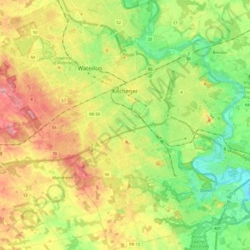
Nome: Mapa topográfico Kitchener, altitude, relevo.
Local: Kitchener, Region of Waterloo, Ontario, Canada (43.35388 -80.57346 43.50683 -80.37841)
Altitude média: 336 m
Altitude mínima: 272 m
Altitude máxima: 419 m
Obrigado por apoiar este site ❤️
Faça uma doação
Faça uma doação