
Obrigado por apoiar este site ❤️
Faça uma doação
Faça uma doação
Mapa topográfico Mount Olympus
Clique no mapa para exibir a altitude.
Obrigado por apoiar este site ❤️
Faça uma doação
Faça uma doação
Sobre este mapa
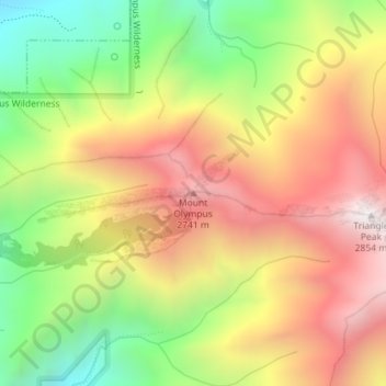
Nome: Mapa topográfico Mount Olympus, altitude, relevo.
Local: Mount Olympus, Salt Lake County, Utah, United States (40.65674 -111.77113 40.65684 -111.77103)
Altitude média: 2.292 m
Altitude mínima: 1.702 m
Altitude máxima: 2.855 m
Obrigado por apoiar este site ❤️
Faça uma doação
Faça uma doação
Outros mapas topográficos
Clique em um mapa para visualizar sua topografia, sua altitude e seu relevo.
Kearns
United States > Utah > Salt Lake County
Kearns, in the mid to late twentieth century, saw rapid growth on the former airbase. The old streets and foundations of buildings built by the military were used as a template for the town, and homes sprang up quickly as Kearns was becoming the first suburb in Salt Lake County. By the 1970s and into the…
Altitude média: 1.408 m
Obrigado por apoiar este site ❤️
Faça uma doação
Faça uma doação