
Mapa topográfico Horanadu
Mapa interativo
Clique no mapa para exibir a altitude.
Sobre este mapa
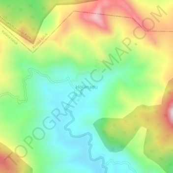
Nome: Mapa topográfico Horanadu, altitude, relevo.
Altitude média: 1.022 m
Altitude mínima: 761 m
Altitude máxima: 1.430 m
Hornadu, also known as Horanadu, is a Hindu holy locale and also a jain holy center Panchayat village located in kalasa taluk of Chikkamagaluru district, Karnataka, India. The deity at the Annapoorneshwari Temple at Hornadu is Annapurneshwari. The main deity of the goddess was put in place by Adi Shankaracharya; the new deity of goddess Annapurneshwari was consecrated in the temple in 1973. Horanadu has an elevation of 831 m (2,726 ft)
Outros mapas topográficos
Clique em um mapa para visualizar sua topografia, sua altitude e seu relevo.
Kudremukha
India > Karnataka > Kalasa taluk
Kudremukha, Kalasa taluk, Chikkamagaluru District, Karnataka, India
Altitude média: 858 m
Kalasa
India > Karnataka > Kalasa taluk
Kalasa, Kalasa taluk, Chikkamagaluru District, Karnataka, 577124, India
Altitude média: 897 m