
Obrigado por apoiar este site ❤️
Faça uma doação
Faça uma doação
Mapa topográfico Punalur
Clique no mapa para exibir a altitude.
Obrigado por apoiar este site ❤️
Faça uma doação
Faça uma doação
Punalur
Punalur has an average elevation of 56 metres (184 ft). Many tourists have visited scenic spots along the Kallada River. The Palaruvi Falls is 35 kilometres (22 mi) from Punalur. The first planned eco-tourism project in Kerala is only 20 kilometres (12 mi) from Punalur on NH 744 towards Sengottai.
Obrigado por apoiar este site ❤️
Faça uma doação
Faça uma doação
Sobre este mapa
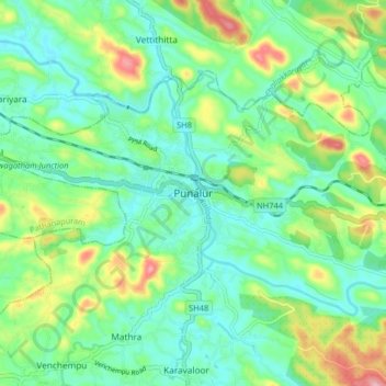
Nome: Mapa topográfico Punalur, altitude, relevo.
Local: Punalur, Kollam District, Kerala, 691305, India (8.97746 76.88648 9.05746 76.96648)
Altitude média: 63 m
Altitude mínima: 13 m
Altitude máxima: 182 m
Obrigado por apoiar este site ❤️
Faça uma doação
Faça uma doação
Outros mapas topográficos
Clique em um mapa para visualizar sua topografia, sua altitude e seu relevo.