
Faça uma doação
Mapa topográfico Golden Gate Park
Clique no mapa para exibir a altitude.
Faça uma doação
Golden Gate Park
In the 1860s, San Franciscans began to feel the need for a spacious public park similar to Central Park, which was then taking shape in New York City. Golden Gate Park was carved out of unpromising sand and shore dunes that were known as the Outside Lands, in an unincorporated area west of San Francisco's then-current borders. In 1865, Frederick Law Olmsted proposed a plan for a park using native species suited for San Francisco's dry climate; however, the proposal was rejected in favor of a Central Park-style park needing extensive irrigation. Conceived ostensibly for recreation, the underlying purpose of the park was housing development and the westward expansion of the city. The tireless field engineer William Hammond Hall prepared a survey and topographic map of the park site in 1870 and became its commissioner in 1871. He was later named California's first state engineer and developed an integrated flood control system for the Sacramento Valley. The park drew its name from nearby Golden Gate Strait.
Faça uma doação
Sobre este mapa
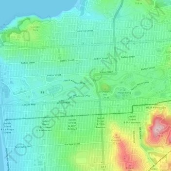
Nome: Mapa topográfico Golden Gate Park, altitude, relevo.
Local: Golden Gate Park, San Francisco, California, United States (37.76414 -122.51087 37.77465 -122.45318)
Altitude média: 71 m
Altitude mínima: -1 m
Altitude máxima: 272 m
Faça uma doação
Outros mapas topográficos
Clique em um mapa para visualizar sua topografia, sua altitude e seu relevo.
San Francisco Bay Area
United States > California > San Francisco
The San Francisco Bay Area is characterized by a diverse and dynamic topography shaped by geological processes over millions of years. This region features a combination of coastal plains, steep hills, and rugged mountains, all influenced by the tectonic activity associated with the nearby San Andreas Fault…
Altitude média: 113 m
San Francisco Bay Area
United States > California > San Francisco
The borders of the San Francisco Bay Area are not officially delineated, and the unique development patterns influenced by the region's topography, as well as unusual commute patterns caused by the presence of three central cities and employment centers located in various suburban locales, has led to…
Altitude média: 113 m
Faça uma doação
Faça uma doação
Faça uma doação