
Faça uma doação
Mapa topográfico MacLean Settlement Brook
Clique no mapa para exibir a altitude.
Faça uma doação
Sobre este mapa
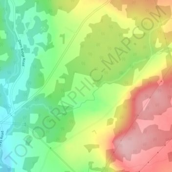
Nome: Mapa topográfico MacLean Settlement Brook, altitude, relevo.
Altitude média: 103 m
Altitude mínima: 20 m
Altitude máxima: 200 m
Faça uma doação
Outros mapas topográficos
Clique em um mapa para visualizar sua topografia, sua altitude e seu relevo.
Manners Sutton Parish
Canada > New Brunswick > York County > Harvey Rural Community
Altitude média: 138 m
Kingsclear Parish
Canada > New Brunswick > York County > Hanwell Rural Community
Altitude média: 109 m
Faça uma doação
Faça uma doação
City of Fredericton
Canada > New Brunswick > York County
At an altitude of about 17 m (56 ft) above sea level, Fredericton is nestled in the Pennsylvanian Basin. It differs markedly from the geologically older parts of the province. There are prominently two distinct areas in the region that are divided around the area of Wilsey Road, in the east end of the city. In…
Altitude média: 73 m
Fredericton
Canada > New Brunswick > York County
At an altitude of about 17 m (56 ft) above sea level, Fredericton is nestled in the Pennsylvanian Basin. It differs markedly from the geologically older parts of the province. There are prominently two distinct areas in the region that are divided around the area of Wilsey Road, in the east end of the city. In…
Altitude média: 73 m
Faça uma doação