
Mapa topográfico Weatherford
Mapa interativo
Clique no mapa para exibir a altitude.
Sobre este mapa
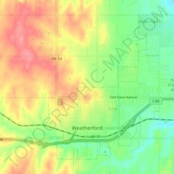
Nome: Mapa topográfico Weatherford, altitude, relevo.
Local: Weatherford, Custer County, Oklahoma, 73096, United States (35.51512 -98.72516 35.56602 -98.64992)
Altitude média: 514 m
Altitude mínima: 472 m
Altitude máxima: 562 m
Weatherford is located at 35°32′18″N 98°41′14″W / 35.53833°N 98.68722°W / 35.53833; -98.68722 (35.5384097, -98.6872467). The elevation is 1,634 feet (498 m). According to the United States Census Bureau, the city has a total area of 7.05 square miles (18.3 km2), all land.
Outros mapas topográficos
Clique em um mapa para visualizar sua topografia, sua altitude e seu relevo.
Moorewood
United States > Oklahoma > Custer County
Moorewood, Custer County, Oklahoma, United States
Altitude média: 557 m
Thomas
United States > Oklahoma > Custer County
Thomas, Custer County, Oklahoma, 73669, United States
Altitude média: 535 m
Arapaho
United States > Oklahoma > Custer County
Arapaho, Custer County, Oklahoma, 73620, United States
Altitude média: 494 m
Clinton
United States > Oklahoma > Custer County
Clinton, Custer County, Oklahoma, 73601, United States
Altitude média: 481 m
Weatherford
United States > Oklahoma > Custer County > Weatherford > Weatherford
Weatherford, Custer County, Oklahoma, 73096, United States
Altitude média: 517 m