
Obrigado por apoiar este site ❤️
Faça uma doação
Faça uma doação
Mapa topográfico Tahuata
Clique no mapa para exibir a altitude.
Obrigado por apoiar este site ❤️
Faça uma doação
Faça uma doação
Tahuata
The land area of Tahuata is 61.0 km2 (23.6 sq mi). The highest point on the island is Mount Amatea (French: Mont Amatea), rising to an elevation of 1,050 m (3,445 ft.). The island is very mountainous, with deep valleys and cliffs. The orography does not allow the construction of an airstrip and communications are by sea from the neighboring island of Hiva Oa, separated by the Bordelais channel 3 km wide and currents of 2 knots.
Obrigado por apoiar este site ❤️
Faça uma doação
Faça uma doação
Sobre este mapa
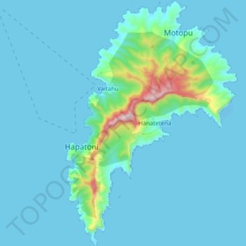
Nome: Mapa topográfico Tahuata, altitude, relevo.
Altitude média: 80 m
Altitude mínima: -8 m
Altitude máxima: 918 m
Obrigado por apoiar este site ❤️
Faça uma doação
Faça uma doação