
Faça uma doação
Mapa topográfico Aspet
Clique no mapa para exibir a altitude.
Faça uma doação
Aspet
Located in the middle of the Pyrenees mountain chain, within the ancient region of Comminges, Aspet sits 15 km south to Saint-Gaudens and at the foot of the Cagire (1,912 metres (6,273 ft) in Altitude).
Faça uma doação
Sobre este mapa
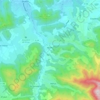
Nome: Mapa topográfico Aspet, altitude, relevo.
Altitude média: 583 m
Altitude mínima: 385 m
Altitude máxima: 1.340 m
Faça uma doação
Outros mapas topográficos
Clique em um mapa para visualizar sua topografia, sua altitude e seu relevo.
Faça uma doação
Toulouse
France > Occitania > Haute-Garonne > Toulouse
The first half of the 14th century was a prosperous period, despite the dismemberment in 1317 of the very large bishopric of Toulouse (which lost two thirds of its area and a large part of its income, a loss only partially compensated by its elevation to the rank of archbishopric), and the episode of the…
Altitude média: 173 m