

Mapa topográfico Pagudpud
Clique no mapa para exibir a altitude.
Pagudpud
The town's topography includes mountains, hills, valleys and flat coastal land.
Sobre este mapa
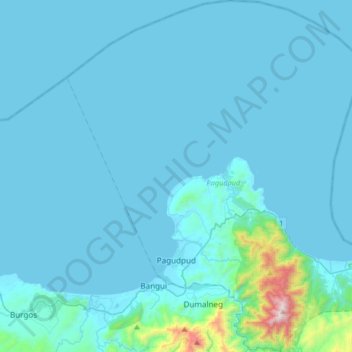
Nome: Mapa topográfico Pagudpud, altitude, relevo.
Local: Pagudpud, Ilocos Norte, Ilocos Region, 2919, Philippines (18.47765 120.65501 18.78619 120.97085)
Altitude média: 73 m
Altitude mínima: -1 m
Altitude máxima: 1.269 m
Outros mapas topográficos
Clique em um mapa para visualizar sua topografia, sua altitude e seu relevo.

Piddig
Piddig's terrain is primarily hilly, with rice plains interspersed in between. It sits at an elevation higher than most towns in Ilocos Norte. The terrain is ideal for hiking given its variety of rivers, forests, and fields.
Altitude média: 55 m

Badoc
The celebrated Philippine painter Juan Luna was baptized in Badoc Church on 27 October 1857. At present, the church houses the miraculous statue of the Blessed Virgin Mary venerated under the title Virgin of Miracles, crowned by Catholic bishops in 1980, and was granted a Canonical coronation by Pope Francis…
Altitude média: 20 m















San Agustin Mini Dam, San Agustin, Paoay, Ilocos Norte
Philippines > Ilocos Norte > Batac
Altitude média: 16 m







Badoc
The celebrated Philippine painter Juan Luna was baptized in Badoc Church on 27 October 1857. At present, the church houses the miraculous statue of the Blessed Virgin Mary venerated under the title Virgin of Miracles, crowned by Catholic bishops in 1980, and was granted a Canonical coronation by Pope Francis…
Altitude média: 20 m
Burgos
Another tourist attraction worth mentioning is the historic Cape Bojeador Lighthouse, built during the latter part of the 19th cent South China Sea, it serves as a beacon to passing ships and to local fishermen. Because of its high elevation, it offers travelers with a panoramic view of the rugged coastline of…
Altitude média: 85 m
Piddig
The Municipality of Piddig's terrain is primarily hilly, with rice plains interspersed in between. It sits at an elevation higher than most towns in Ilocos Norte. The terrain is ideal for hiking given its variety of rivers, forests, and fields.
Altitude média: 55 m
Adams
The shield was derived from the Provincial Seal of Ilocos Norte. The mountain range and the verdant field and river show the topography of the place as a potential source of wealth and livelihood. The mountain ranges also symbolizes the lofty ideals and the high hopes of the people for making Adams a…
Altitude média: 517 m
